- Physical Features of India
- Choose the right answer from the four alternatives given below:
(i) A landmass bounded by sea on three sides is referred to as:
a) Coast
b) Island
c) Peninsula
d) None of the above
Ans. c) Peninsula
The part of India below Tropic of Cancer is also named as Peninsular India. It is bounded by Arabian Sea in south west, Indian Ocean in South and Bay of Bengal in south east.
(ii) Mountain ranges in the eastern part of India forming its boundary with Myanmar are collectively called as:
a) Himachal
b) Uttaranchal
c) Purvanchal
d) None of the above
Ans. c) Purvanchal
Beyond the Dihang Gorge, the Himalayas bend sharply to the south and spread along the eastern boundary of India, with the name of Purvanchal.
(iii) The western coastal strip South of Goa is referred to as:
a) Coromandel
b) Konkan
c) Kannad
d) Northern Circar
Ans. c) Kannad
The western coastal strip is divided into three parts Konkan, Kannad and Malabar Coast.
(iv) The highest peak in the Eastern Ghats is:
a) Annai Modi
b) Kanchanjanga
c) Mahendragiri
d) Khasi
Ans. c) Mahendragiri
The highest peak in the Eastern Ghats is Mahendragiri with a height of 1501 metres.
- Answer the following questions briefly:
(i) What is bhabar?
Ans. The rivers, after descending from the mountains, deposit pebbles in a narrow belt of about 8 to 16 kilometre in a line parallel to the slopes of the Shivaliks. It is known as bhabar.
(ii) Name the 3 major divisions of Himalayas from north to south.
Ans. The 3 major divisions of Himalayas from north to south are:
a) Himadri
b) Himachal
c) Shivaliks
(iii) Which plateau lies between the Aravali and the Vindhya Ranges?
Ans. Malwa Plateau lies between the Aravali and Vindhya ranges.
(iv) Name the island groups of India having coral origin.
Ans. The island groups of India having coral origin are Lakshadweep Islands.
- Distinguish between:
(i) Converging and diverging tectonic plates.
| Converging tectonic plates | Diverging tectonic plates |
| Some plates come towards each other and form convergent boundary. | Some plates move away from each other and form divergent boundary. |
(ii) Bhangar and Khadar
| Bhangar | Khadar |
| The largest part of the Northern Plane is formed of older alluvium. They lie about the flood plains of the rivers and present a terrace like feature. This part is known as Bhangar. | The soil in this region contains calcareous deposits locally done as Kankar. The newer, younger deposits of the flood plains are called Khadar. They are renewed almost every year and so are very fertile. Ideal for intensive agriculture. |
(iii) Western Ghats and Eastern Ghats
| Western Ghats | Eastern Ghats |
| a) The Western Ghats are higher than the Eastern Ghats. Their average elevation is 900 to 1600 meters as against 600 meters of the Eastern Ghats. b) The Western Ghats are continuous and can be crossed through Thal, Bhor and Pal Passes. Western Ghats are higher than the Eastern Ghats. c) The highest peaks include the Anamudi (2695 meters) and Doddabetta the (2637 meters). d) The height of the Western Ghats progressively increases from north to south. e) The Western Ghats are known by different local names. f) The Western Ghats cause orographic rain by facing the rain bearing moist winds to rise along the western slopes of the Western Ghats. | a) The Eastern Ghats have an average height of 600 meters and stretch from the Mahanadi valley to the Nilgiri in the south. b) The Eastern Ghats are discontinuous and irregular and dissected by rivers draining into Bay of Bengal.
c) Mahendragiri (1501 meters) is the highest peak in the Eastern Ghats.
d) The Eastern Ghats are lower than the Western Ghats.
e) Shevaroy Hills and the Javadi Hills are located to the southeast of the Eastern Ghats.
|
- Which are the major physiographic divisions of India? Contrast the relief of the Himalayan region with that of the Peninsular Plateau.
The physical features of India can be grouped under the following physiographic divisions:
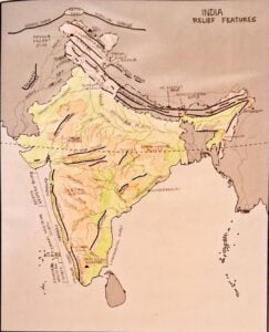
a) The Himalayan Mountains
b) The Northern Plains
c) The peninsular Plateau
d) The Indian Desert
e) The Coastal Plains
f) The Islands Group
The Himalayas consists of three parallel ranges in its longitudinal extent. A number of valleys lie between these ranges.
The northernmost range is known as the Great or Inner Himalayas or the Himadri. It is the most continuous range, consisting of the loftiest peaks and an average height of 6000 meters. It contains all the prominent Himalayan peaks.
Himalayas are the youngest fold mountains.
The range lying to the south of Himadri forms the most rugged mountain system and is known as the Himachal or Lesser Himalayas.
The outer range of Himalayas is known as the Shivaliks.
The Peninsular Plateau is divided into two parts.
a) Central Highlands
b) Deccan Plateau
The peninsular plateau is a table land composed of the old crystalline, igneous and metamorphic rocks. It was formed due to the breaking and drifting of the Gondwana land and thus making it a part of the oldest landmass.
The part of the peninsular plateau lying to the north of the Narmada River, covering a major area of the Malwa Plateau, is known as the Central Highlands. The Malwa Plateau is bounded by the Vindhya Range to the South and the Aravali to the North West. The further westward extension gradually merges with the sandy and rocky deserts of Rajasthan. The eastward extension of this plateau is locally known as the Bundelkhand and Baghelkhand. The Chhota Nagpur plateau marks the further eastward extension drained by the Damodar River.
The Deccan Plateau Is a triangular land mass that lies to the South of the river Narmada. Satpura Range flanks its broad base in the north, while the Mahadev, the Kaimur Hills and the Maikal Range form its eastern extensions. The Deccan Plateau is higher in the West and slopes gently eastward. An extension of the plateau is also visible in the northeast, locally known as the Meghalaya and Karbi Anglong Plateau. It is separated by a fault from the Chhota Nagpur plateau. Three prominent hill ranges from the west to east are the Garo, Khasi and Jaintia hills in Meghalaya. The Western Ghats and Eastern Ghats mark the Western and Eastern edges of the Deccan Plateau respectively. The Western Ghats are higher than the Eastern Ghats.
- Give an account of the Northern Plains of India.
a) Northern Plains has been formed by the interplay of the three major river systems namely, the Indus, the Ganga and Brahmaputra, along with their tributaries. This plain is formed of alluvial soil. The deposition of alluvium in a vast basin line at the foothills of the Himalayas over millions of years formed this fertile plain.
b) It spreads over an area of 7, 00,000 square kilometers, the plain being about 2400 kilometer long and 240 to 320 kilometers broad, is a densely populated physio-graphic division. With the rich soil cover combined with adequate water supply and favorable climate, it is agriculturally a very productive part of India.
c) The rivers in their lower course split into numerous channels due to the deposition of silt. These channels are known as dis-tributaries.
d) The northern plain is broadly divided into three sections. The western part of the northern plain is referred to as the Punjab plains. Formed by the Indus and its tributaries, the larger part of this plain lies in Pakistan.
e) The Indus and its tributaries, the Jhelum, the Chenab, the Ravi, the Bias and the Sutluj originate in the Himalaya. This section of the plain is dominated by doabs.
f) The Ganga plane extends between Ghaggar and Tista rivers. It is spread over the states of North India, Haryana, Delhi, Uttar Pradesh, Bihar, partially Jharkhand and West Bengal to its east. Particularly in Assam lies the Brahmaputra plain.
- Write short notes on the following.
i) The Indian Desert
ii) The Central Highlands
iii) The island groups of India
(i) The Indian Desert:
a) The Indian desert lies towards the western margins of the Aravali Hills.
b) It is an undulating, sandy plane covered with sand dunes.
c) This region receives very low rainfall, below 150 mm per year.
d) It has arid climate with low vegetation cover.
e) Streams appear during the rainy season. Soon after, they disappear into the sand as they do not have enough water to reach the sea.
f) Luni is the only large river in this region.
g) Barchans (Crescent shaped dunes) cover larger areas, but longitudinal dunes become more prominent near the Indo- Pakistan boundary.
(ii) The Central Highlands:
The Peninsular plateau consists of two broad divisions, namely
a) Central Highlands
b) Deccan Plateau
i) Central Highlands: is bounded by the Vindhya Range in the south and the Aravalis to the northwest. The further extension in west gradually merges with the sandy and rocky desert of Rajasthan.
ii) The flow of the rivers during this region, namely the Chambal, Sind, Betwa and Ken, is from South West to North East, thus indicating the slope.
iii) The central Highlands are wider in the West but narrower in the east. The eastward extension of this plateau is locally known as the Bundelkhand and Baghelkhand. The Chhota Nagpur plateau marks the further eastward extension drained by the Damodar River.
(iii) The island groups of India:
Lakshadweep Islands
i) This group of island is composed of small coral islands. Earlier, they were known as Laccadive, Minicoy and Amindive. In 1973, these were named as Lakshadweep. It covers small area of 32 square kilometres. Kavaratti Island is the administrative headquarters of Lakshadweep.
ii) This island group has great diversity of flora and fauna. The Pitti Island, which is uninhabited, has a bird Century.
Andaman and Nicobar Islands
i) An elongated chain of islands located in the Bay of Bengal, extending from the north to the South. These are Andaman and Nicobar Islands. They are bigger in size and are more numerous and scattered. The entire group of this island is divided into two broad categories. The Andaman in the north and the Nicobar in the South.
ii) It is believed that these islands are an elevated portion of submarine mountains.
iii) These island groups are a great strategic importance for the country. There is great diversity of flora and fauna in this group of islands too.
iv) These islands lie close to the equator and experience Equatorial climate and have thick forest cover.
v) The 10˚ Channel separates the Andaman from Nicobar Islands.
Extra Questions:
- What are tectonic plates?
Ans.
a) The crust, upper part of the earth has been formed out of seven major and some minor plates. These are called tectonic plates.
b) A tectonic plate, also called lithospheric plate, is a massive irregularly shaped slab of solid rock generally composed of both continental and oceanic lithosphere.
c) Plate size can vary greatly from a few 100 to 1000 of kilometres across.
d) The Pacific and Antarctic plates are among the largest.
e) Plate thickness also varies greatly, ranging from less than 15 kilometres from oceanic lithosphere to about 200 km or more for ancient continental lithosphere.
- Which continents of today were parts of Gondwana land?
Ans.
a) The oldest landmass, the peninsula part was a part of the Gondwana land.
b) The Gondwanaland included India, Australia, South Africa and South America as one single Landmass.
- Name the four major divisions of Himalayas from west to east.
Ans. The four major divisions of Himalayas from West to East are:
a) River Indus to Sutluj – Kashmir Himalayas or Punjab Himalayas
b) River Sutluj to Kali – Kumaon Himalayas or Himachal Himalayas
c) River Kali to Tista – Nepal Himalayas
d) River Kali to Dihang – Assam Himalayas
- Describe how the Himalayas were formed.
Ans.
a) The Himalaya Mountains and Tibetan Plateau were formed with the collision of Indian plate and Eurasian Plate.
b) Himalayas are the result of three different upheavals in different periods.
c) The Himalayas and the northern plains are the most recent landforms from the viewpoint of geology.
d) Himalayan mountains form an unstable zone.
e) The whole mountain system of Himalaya represents a very youthful topography with high peaks, deep valleys and fast flowing rivers.
f) The Himalayas consists of three parallel ranges, the Himadri, the Himachal and the Shivaliks.
- Name the glaciers and passes that lies in the Great Himalayas.
Ans.
Glaciers – Gangotri, Chaturangi, Bhagirathi, Satopnath, Kamet, Milam, Pindari glaciers.
Passes – Karakoram, Shipkila, Nathula, Bomdila.
- Designate Purvanchal hills.
Ans.
a) The Purvanchal is covered with dense forest.
b) They are the clutches of sandstone and sediments.
c) Purvanchal comprises the Patkai Hills, the Naga Hills, Manipur Hills and Mizoram Mizo Hills.
- What is coral? What makes up the habitat in which coral polyps flourish?
Ans. Corals are small sedimentary marine animals that live in colonies. The coral polyps flourish in a habitat consisting of shallow, warm water which does not have mud. This kind of habitat is found in Lakshadweep.
- Why do Shivaliks face frequent landslide?
Ans. The Shivaliks are composed of unconsolidated sediments brought down by rivers from the main Himalayan ranges and thus are prone to landslide.
- The state of Meghalaya forms an extension of which physiographic division of India.
Ans. Meghalaya is an extension of Deccan Plateau locally known as Karbi-Anglong Plateau and North Cachar Hills. It is separated by a fault from Chota Nagpur Plateau.
- Which is the most important and longest mountain range of Himalaya?
Ans. Pir Panjal Range forms the longest and the most important range of Himachal Himalayas.
- The northern plain primarily is known as agricultural belt. Why?
Ans. Northern Plains have a thick soil cover composed of fine silt or alluvium brought down by the Himalayan Rivers. This alluvial soil is very fertile; hence this is primarily an agricultural belt.
- What are duns made up of? Give an example of dun.
Ans. The longitudinal valley lying between Lesser Himalaya and Shivalik are known as Duns. These are made up of gravel and alluvium soil. The Dehradun, Kotli dun, Patli dun valley are examples of duns.
- What is Barchan?
Ans. Barchans are crescent shaped sand dunes pointing downwards. Mostly found in Jaisalmer, Rajasthan.
- Mention any two characteristics of the Aravalli Ranges.
Ans.
a) The Aravalli ranges are eroded hills.
b) They give pass to a branch of Arabian Sea South West monsoon winds.
They extend from Gujarat to Delhi in a South West to North East direction.
- The diverse physical features of India are of immense value, justify the statement.
Ans.
a) The northern mountains are the major source of water and forest cover.
b) The northern plains are the granaries of the country.
c) The southern plateau is a storehouse of minerals. This has played a crucial role in the industrialisation of the country.
d) The coastal region and island groups provide sites for fishing, recreation and port activities.
e) The deserts are the storehouse of solar and wind energy.
- Compare between eastern coastal plains and western coastal plains.
Ans.
| Western coastal plain | Eastern coastal plains |
| a) It is in plain with an average width of about 64 km. b) The plain is located between the Western Ghat and the Arabian Sea coast. c) The plain is divided into three parts Konkan (Mumbai – Goa) Kannad and Malabar Coast. d) No big deltas are formed here. River Narmada and Tapi form estuaries.
| a) It is comparatively broader plain with average width of around 80 to 100 km. b) The plain is located between the Eastern Ghats and the coast of Bay of Bengal. c) The plain is divided into two parts, Northern Circar and Coromandel Coast.
d) Large deltas are formed by rivers like Mahanadi, Godavari, Krishna, Kaveri and some small rivers.
|
—x—x—x—